
数字孪生城市智能感知
·
一、界面搭建
- 使用vue2+Cesium开源引擎开发;
- UI组件使用iview、echarts等;
二、实现功能
2.1 可视化菜单:
2.1.1 移动平台运行轨迹
- 无人机飞行仿真

//加载无人机路径函数
startAnalyse() {
  if (drone) {
    drone.EndRoaming();
    console.log('delete drone')
  }
  let shpPath;
  if (this.droneForm.roadLines === 'uavlines') {
    shpPath = "static/shp/drone/uavline092301.shp";
  } else {
    shpPath = this.upLoadData
  }

  let position1 = Cesium.Cartesian3.fromDegrees(
    112.62,
    30.29,
    0
  );

  if(this.viewer.entities.getById('cugBuildings')){
    this.viewer.entities.removeById('cugBuildings')
  }

  let buildings = this.viewer.entities.add({
    id: 'cugBuildings',
    position: position1,
    model: {
      uri: "static/models/building_0.glb",
      minimumPixelSize: 1000,
      maximumScale: 2000,
    },
  });
  /* 加载线数据 */
  let ds6 = shpToGeojson(
    this.viewer,
    shpPath,
    [1.0, 0.0, 0.0, 1.0],
    "线",
    0.0,
    "polyline"
  );
  let position;
  let velocity = parseInt(this.droneForm.velocity)

  let startPoint = parseInt(this.droneForm.startPoint)
  ds6.then((res) => {
    let dataSource = res[0];
    let polyline = res[1][0].polyline;
    position = polyline.positions._value;
    drone = new DroneRoaming(this.viewer, {
      name: "无人机1",
      pathColor: Cesium.Color.YELLOW,
      uri: `static/models/CesiumDrone.glb`,
      velocity: velocity, //km/h
      position: position,
      startPoint: startPoint,
      startTime: this.droneForm.date1,
      dataSource: dataSource,
      sensorType:this.droneForm.sensorType,
      scanItem: [
        {
          type: "建筑物",
          lon: -112,
          lat: 30,
          sum: 85,
        },
      ],
    });
    console.log(drone.startTime)
    console.log(this.droneForm.date1)
  });
},
- 卫星轨迹模拟
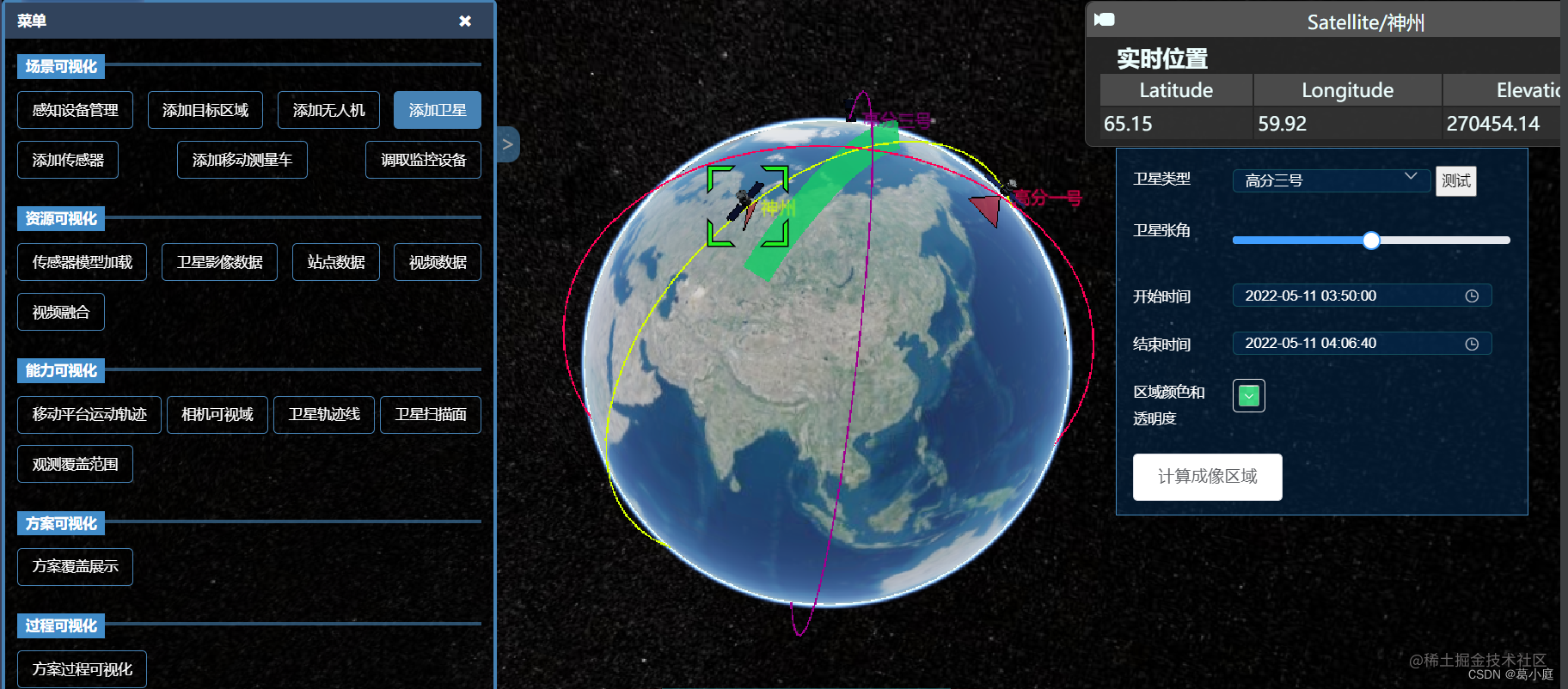
//卫星扫描
CalScan() {
  let arr = this.satForm.color
    .split("(")[1]
    .split(")")[0]
    .split(",");
  let r = parseFloat(arr[0]);
  let g = parseFloat(arr[1]);
  let b = parseFloat(arr[2]);
  let a = parseFloat(arr[3]);
  this.satModel.forEach((item) => {
    if (item.sat) {
      let sat1;
      item.sat.then(res => {
        if(this.viewer.entities.getById(res.name+'tri')){
          this.viewer.entities.removeById(res.name+'tri')
        }
        let ellipsoid = this.viewer.scene.globe.ellipsoid;
        sat1 = res.entities.getById(item.id);
        let time = this.viewer.clock.startTime;
        let posArr=this.timePositionChange(sat1,time,ellipsoid)//卫星开始时间的经纬度

        //扫描线
        let coordinates = [];
        let julian_start = Cesium.JulianDate.fromDate(this.satForm.startTime);
        let julian_end = Cesium.JulianDate.fromDate(this.satForm.endTime);
        for (let ind = 0; ind < 292; ind++) {
          let current = Cesium.JulianDate.addSeconds(julian_start, 300 * ind, new Cesium.JulianDate());
          if(Cesium.JulianDate.lessThanOrEquals(current,julian_end)){
            let LineArr=this.timePositionChange(sat1,current,ellipsoid)
            coordinates.push(...LineArr)
          }else{
            break;
          }
        }
        let yellowLine = this.viewer.entities.add({
          id: res.name,
          polyline: {
            positions:Cesium.Cartesian3.fromDegreesArray(coordinates),
            width: new Cesium.CallbackProperty(()=>{
              return this.satForm.triAngle/2
            },false),
            material: new Cesium.Color(r / 255, g / 255, b / 255, a),
          },
        });
      })
    }
  });
},
2.1.2 感知资源可视化
- 站点模型加载
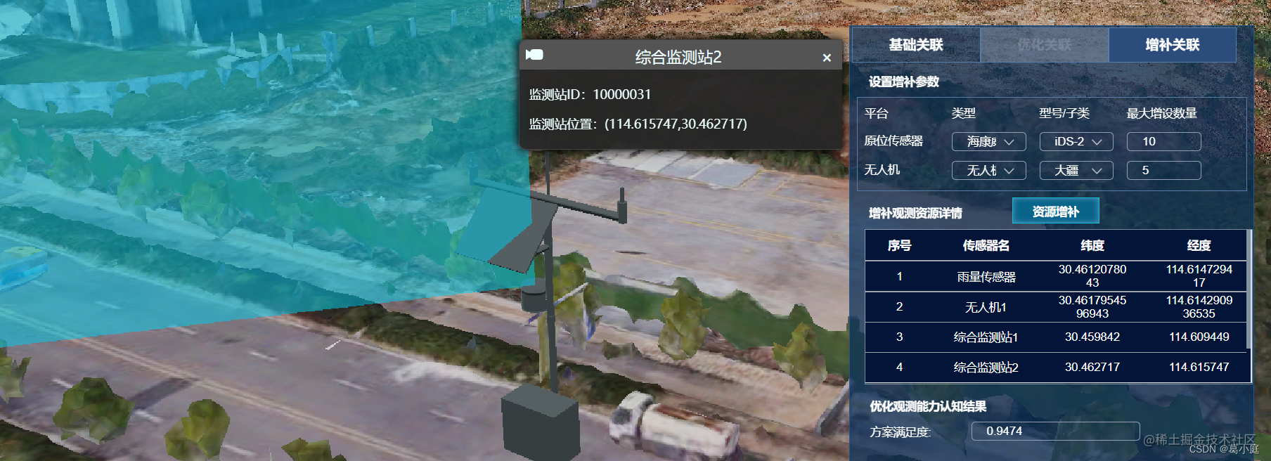
- 三维模型(以综合监测站模型为例,加入雷达扫描效果)
- 二维站点(融合各种类型传感器进入三维场景,但高度还不太准确,有待优化)
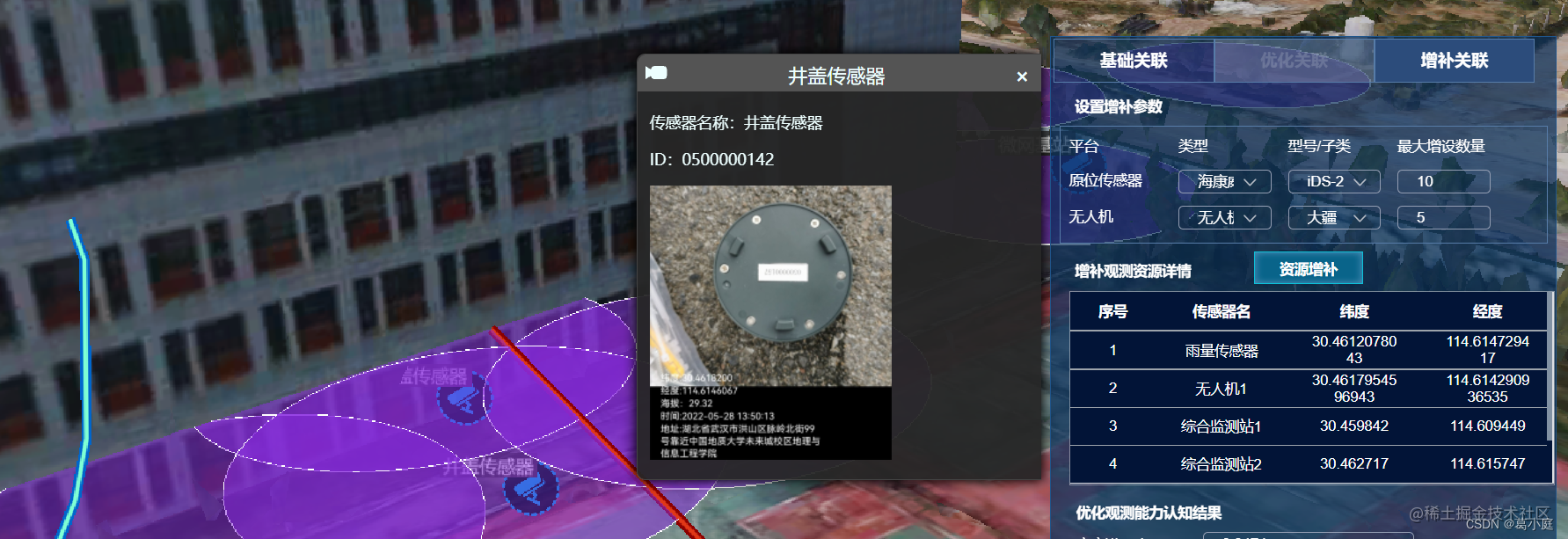
上图为RFID原位传感器样例
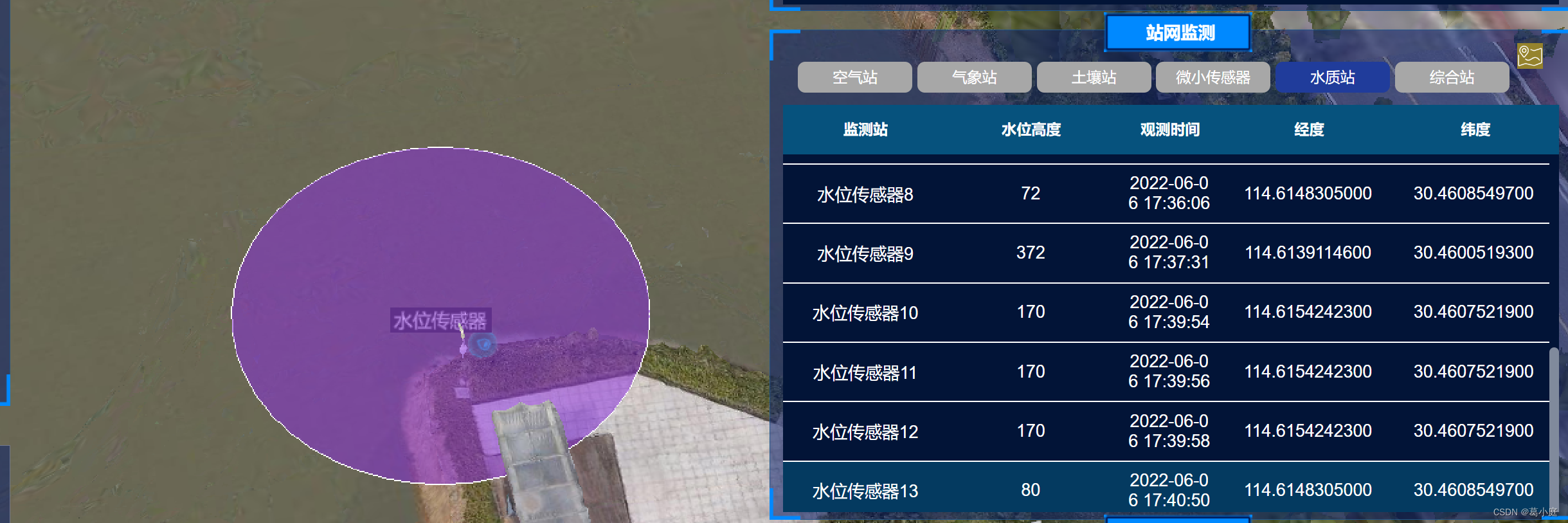
上图为水位传感器样例
- 视频数据加载:
这里使用了纯前端空间体体积计算工具
DEJA_VU3D - Cesium功能集 之 050-纯前端空间体体积计算 - 小专栏 (xiaozhuanlan.com)
目前只实现了普通的二维平面融合,后续准备继续尝试边缘模糊和纹理处理。进行三维融合。
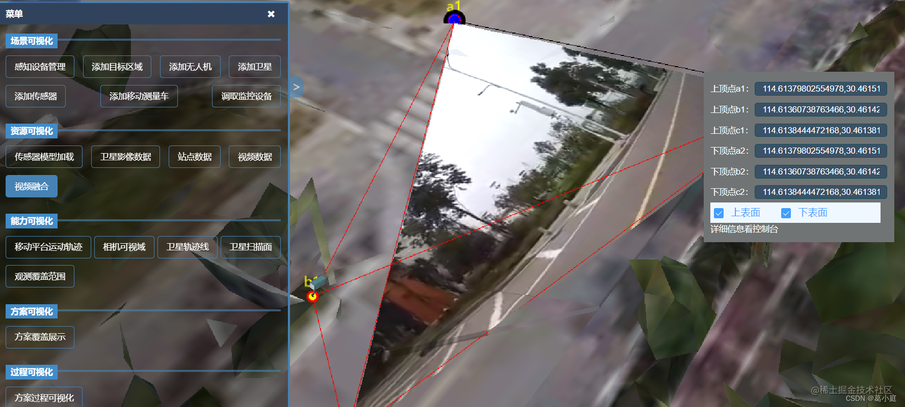
//视频融合
setVideoFusion(){
  // 添加贴地的多边形,设置video为其材质
  this.videoShow =! this.videoShow
  this.load3dTilesWL()
  this.initPoints()

  this.viewer.entities.add({
    position:Cesium.Cartesian3.fromDegrees(114.61360738763466,30.461423820341555,2.5),
    model:{
      uri : 'static/models/security_camera/scene.gltf', // 资源路径
      scale:0.001
    },
    orientation: Cesium.Transforms.headingPitchRollQuaternion(
      Cesium.Cartesian3.fromDegrees(114.61360738763466,30.461423820341555,2.5),
      new Cesium.HeadingPitchRoll(
        Cesium.Math.toRadians(90),
        Cesium.Math.toRadians(0),//俯仰角的值
        Cesium.Math.toRadians(0)//翻滚角
      )
    ),
  })

  //创建实例绑定视频dom元素
  let videoElement = document.getElementById('trailer');//获得video对象
  this.viewer.entities.add({
    polygon: {
      hierarchy: Cesium.Cartesian3.fromDegreesArrayHeights([
        114.61360738763466,30.461423820341555,-4,
        114.61379802554978,30.46151654173604,-4,
        114.6138444472168,30.46138124628038,-4,
        114.61360738763466,30.461423820341555,-4,
      ]),
      clampToGround: true,
      material: videoElement,
      classificationType: Cesium.ClassificationType.BOTH
    }
  });
},
2.1.3 感知过程可视化
- 卫星仿真覆盖时间轴
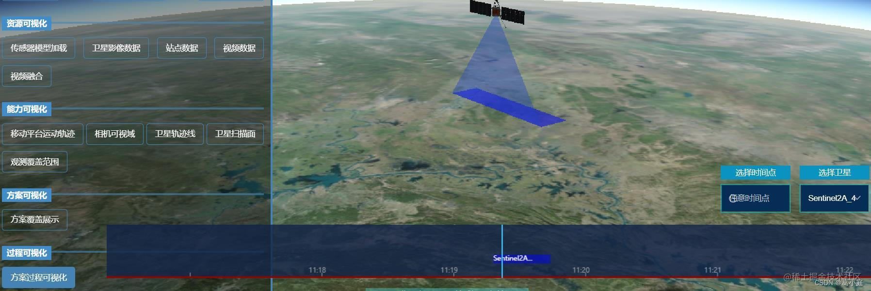 时间轴动态观测并生成覆盖区域
//加载时间轴
document.getElementById("ccanvas").innerHTML =
  "<canvas id='timeline' width='" +
  window.innerWidth * 0.85 +
  "'" +
  "height=" +
  80 +
  "'" +
  " style='cursor: pointer;background-color: rgba(17, 35, 70, 0.8);'></canvas>";
//align-self: flex-end; οndragstart='return false;'

var alldatas = timecell;
this.cells = alldatas.map(function (i) {
  var r = new TimeCell(i);
  r.isCall = 0;
  return r;
});
this.TL = $("#timeline");
this.TL.TimeSlider({
  init_cells: alldatas,
});
this.TL.TimeSlider(this.AutomaticMode());
//设置时间轴的时间
var settime = (nativeTime, location) => {
  clearInterval(this.setTimeMove);
  this.__time = new Date(nativeTime).getTime();
  this.TL.TimeSlider("set_time_to_middle", this.__time);
  this.AutomaticMode();
};
//筛选标签
var filter_tag = (filters) => {
  clearInterval(this.setTimeMove);
  var tmpalldatas = new Array(filters.length);
  if (filters.length > 0) {
    tmpalldatas = alldatas.filter(function (i) {
      if (i.group != null && i.group.search(",") != -1) {
        var j;
        var len = i.group.split(",");
        for (j = 0; j < len.length; j++) {
          if (filters.split(",").indexOf(len[j]) >= 0) {
            return filters.split(",").indexOf(len[j]) >= 0;
          }
        }
      } else {
        return filters.split(",").indexOf(i.group) >= 0;
      }
    });
  } else {
    tmpalldatas = alldatas;
  }
  //重置时间轴
  this.TL.TimeSlider("init", this.__time, tmpalldatas);
  var tmpcells = tmpalldatas.map(function (i) {
    var r = new TimeCell(i);
    r.isCall = 0;
    return r;
  });
  //重置时间轴上的事件
  this.ValueChange(new Date(2020, 2, 18, 14, 23, 30, 0).getTime(), false);
  this.cells = tmpalldatas.map(function (i) {
    var r = new TimeCell(i);
    r.isCall = 0;
    return r;
  });
  this.AutomaticMode;
};
更多推荐
 1
1 0
0- 0


 已为社区贡献1条内容

所有评论(0)